Selway-Bitterroot Wilderness
Updated: August 20, 2020

The Selway-Bitterroot Wilderness, covering 1.3 million acres, is part of the Bitterroot National Forest, Clearwater National Forest, Lolo National Forest, and the Nez Perce National Forest, lying on both sides of the Bitterroot Range. Its boundaries are between Montana and Idaho. It includes large parts of the Lochsa and Selway river drainages.

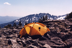
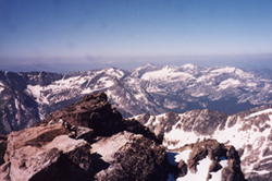
Hundreds of peaks separate more than thirty rugged drainages for nearly ninety miles along a dramatic mountain front stretching from the South Fork of Lolo Creek south to where rocky ridges break abruptly into the West Fork of the Bitterroot River. From the lofty vantage point of any of the 9,000 to 10,000-foot peaks the impression is one of barren rock from the jagged crest of the Bitterroots to the valley floor. A closer look reveals sheer walls, cliffs, tumbling waterfalls, hanging valleys -- landscape so rough that, in comparison, most other Montana mountains seem like gently rolling hills.
Although much of this land is stark and treeless, there are surprising pockets of wildlife. Elk summer in lush basins along the divide and hide in heavily forested canyons during the fall hunting season. The wilderness also has a native bighorn sheep herd in Sheephead and Watchtower creeks.
Updated: August 20, 2020


