

Facts & Figures • Geography
Updated: February 2, 2026
Geography and Maps
Explore Montana’s mountains, plains, rivers, and special landforms using words and maps.
Big Sky over a Big State
Montana is a vast and varied state of mountains, canyons, river valleys, forests, grassy plains, badlands, and caverns. Its “Big Sky” covers a land area of more than 147,000 square miles, making Montana the fourth largest state in the nation.
In area, it can accommodate Virginia, Maryland, Delaware, Pennsylvania, and New York, and still have room for the District of Columbia. Yet Montana’s population is just about 1.15 million people (2026 estimate), making it the sixth least populated state. There are fewer people living in the entire state of Montana than in the city of Phoenix.
Names for a Mountainous Place
Montana is a word derived from the Spanish word meaning “mountainous.” It is often called the “Treasure State” and “Big Sky Country.” All these nicknames refer to the beautiful and diverse landscapes found within Montana’s borders.
The Backbone of the World
Some Native peoples called the Continental Divide the “backbone of the world.” The Divide runs along the crests of the Rocky Mountains from Canada to Mexico, literally splitting the waters of the North American continent.
Montana is known as a headwaters state because much of the water that flows to the rest of the nation comes from its mountains. Within Montana’s borders are parts of two major river drainage systems of North America.
The Kootenai, Clark Fork, Blackfoot, Bitterroot, and Flathead Rivers join the Columbia River, which flows into the Pacific Ocean. From its headwaters at Three Forks, the Missouri River empties into the Mississippi River and then the Gulf of Mexico.
Montana’s two largest lakes are Flathead Lake—the largest natural freshwater lake west of the Mississippi River—and Fort Peck Lake, a man‑made reservoir with more than 1,500 miles of shoreline.
Regions, Parks, and Special Landforms
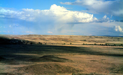
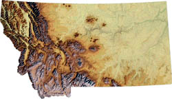
Across Montana are geographic treasures waiting to be discovered. The eastern third of the state is plains country where the sky seems to have no limits. The central third is plains surrounding what are called “island” mountain ranges, and the western third is made up of mountain ranges and valleys.
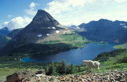
In the south‑central part of the state is Yellowstone National Park, which has the world’s most extensive area of geyser activity and more than 10,000 thermal features. In the northwestern corner is Glacier National Park, where spectacular mountain peaks were carved by ancient glaciers.
In the far eastern part of the state is Makoshika State Park, where strange and beautiful badlands formations give visitors a chance to see rocks shaped by wind, water, and time.
Explore More Montana Maps
See more maps of Montana’s mountain ranges, rivers, reservations, and counties at the Montana Historical Society.
Updated: February 2, 2026