

Facts & Figures • Geography
Updated: February 2, 2026
Highest and Lowest Points
Find out where Montana reaches the sky and where it comes closest to sea level.
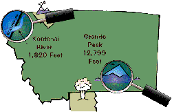
Granite Peak: Montana’s Roof
The highest point in Montana is Granite Peak, located in the Beartooth Range of the Rocky Mountains. It sits near Yellowstone National Park, just north of the border between Wyoming and Montana.
At about 12,799 feet above sea level, Granite Peak is considered one of the most difficult state high‑point climbs in the lower 48 states.
Climbers often set up a base camp on a rugged area of subalpine meadows and boulder fields called the Froze‑to‑Death Plateau before attempting the summit.
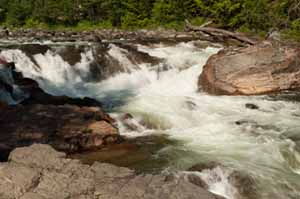
Kootenai River: Montana’s Lowest Point
The lowest point in Montana is where the Kootenai River exits the state in northwest Montana at the Montana–Idaho border, at an elevation of about 1,820 feet above sea level.
The river drops down to this low elevation after going over Kootenai Falls. Above the falls the Kootenai is big, broad, deep, and fast, flowing over China Rapids; below the 30‑foot falls it becomes smaller, with riffles and waves instead of large drops.
Because this stretch of river flows through such a low‑lying valley for Montana, the area can be surprisingly warm during summer months compared to many other parts of the state.
Updated: February 2, 2026